Fall Foliage
By • July 26, 2011 0 1602
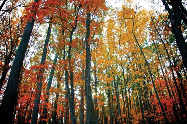
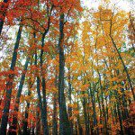
It’s finally autumn. At least that’s what the calendar says. Despite our region’s exceedingly hot and dry weather, the days are shortening and the leaves have begun to change color. In fact, there are only a few weeks until the autumn foliage reaches its peak. This season, the peak is expected to be shorter than usual because of the dryness during the growing season. Hopefully our recent rains will plump up the leaves a bit.
So it’s time to pile the family into your fuel-efficient minivan and hightail it to Skyline Drive to look at the leaves. Right? Just drive straight out route 66 and hang a left on Skyline Drive.
That might be a good plan if you feel like sitting in traffic going five miles an hour along the drive. To be sure, the vistas can be astonishing, and it’s understandable that each driver wants to savor each eyeful. But it can be the Shenandoah equivalent of the gridlock along the Tidal Basin when the Cherry Blossoms bloom. And once you’re on the drive it isn’t so easy to exit in all that traffic. So should you give up on your plans?
The answer is a resounding no! There are numerous ways you can enjoy the spectacular vistas
without crawling along with the kids clamoring to go home. The foliage can be enjoyed from the ground (walking, biking, ATVing, hiking or driving), the water, and the air. The options are near endless. There are myriads of websites and publications to help you find your own wonderland.
By Screen
As we do live in the electronic age, I’ll give a nod to armchair enthusiasts. The National Park Service web site updates the color changes and leaf volumes at various park hotspots weekly (Check it out here). There is an accompanying link to the Leaf Color Cam. With the cam, you can observe real-time color change in multiple areas in the park. Talk about virtual autumn. Grab your Octoberfest beer and your laptop—or better yet, your internet-wired big screen TV—and you’re set.
By Foot
For walkers, hikers and campers, the Shenandoah Valley offers a rich system of trails maintained by national, state and volunteer agencies. Many of these trails join with the Appalachian Trail and can be accessed from within or without the National Park. The National Geographic Society publishes a multi-county map of the Shenandoah Valley replete with hundreds of trails of varying lengths and degrees of difficulty.
As beautiful as it is looking at the panorama of autumn from the Skyline Drive, walking through the woods with the leaves changing and coming upon an amazing lookout is a magnificent way to appreciate nature. With minimal work you can find a trail to suit your stamina and senses. There are trails for meanderers, skilled technical climbers and everyone in between. Here are a few suggestions that are off the beaten path.
William Melson is geologist emeritus at the Smithsonian’s Museum of Natural History. I spoke with him the day after he led a group of local Shenandoah residents along an easy trail atop Powell Mountain, one of the tallest peaks (2000 ft) in the Massanutten range in Woodstock, VA. At the top of the peak is the Woodstock Observation tower, from which one can see for miles into the Shenandoah Valley and take in the snaking seven bends of the North Fork of the Shenandoah River cutting through the valley landscape. Just a few hundred feet past the trailhead for the tower is Melson’s trail. It goes 70 miles in either direction, is an easy walk, and takes you to the spot below the observation tower where the hang gliders jump off. Both trails can be previewed at: www.HikingUpward.com/GWNF/WoodstockTower
Closer to DC, Melson recommends the Bull Run Conservancy Trails off of Rt. 66 in Broad Run, VA. Trails range from .2 to 1.75 miles, and many of them connect so you can create a trail of your own. Maps of the conservancy site are available online.
Folks who have spent most of their lives in the Shenandoah Valley and around the George Washington National Forest know what a jewel Fort Valley is. It is a 23-mile valley to the west of, and paralleling the Skyline drive, surrounded on both sides by arms of the Massanutten Mountains. At the northern end is Elizabeth Furnace, site of one of the most productive pig iron furnaces in the 1800s. The southern end is notable for the site of Camp Roosevelt, the first Civilian Conservation Corps camp created during the depression. Recreation sites and campgrounds are located in both places and trails of all kinds originate in the recreation areas.
I interviewed residents of the Shenandoah Valley, National Park Service personnel, and veteran
hikers. Each individual had his or her own favorite trail, but they all then went on to mention the website HikingUpward.com. I used it to find a trail in the George Washington National Forest. It is a terrific site for locating hiking trails in the Shenandoah Valley. It has detailed topography maps, trail descriptions, hiking tips, guides for identifying flora, pictures along the trail, driving directions and hiking directions. You can click on an area of the map, and it will show the hikes in that area. Truly a remarkable hiking site that is free to the public to use.
By Sea
If driving and hiking don’t pique your interest, you might seriously consider enjoying the outdoors
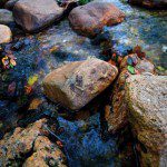
from a canoe. Out on the water, nature surrounds you on all sides. The sounds are limited to the bubbling and rushing of the water, the calls of the birds and waterfowl, the sounds of the animals in the surrounding forest and your own laughter. Eagles, hawks, herons and ducks are bountiful. The trees form a colorful cathedral over the narrower parts of the river. The recent rains have raised the water levels in the North and South Forks of the Shenandoah River, and it’s running somewhat fast with plenty of small rapids. Information regarding river outfitters is available on the web. If you decide to canoe, make sure you bring along a change of clothes in a waterproof bag. The water has cooled, and if you should capsize…well, it could be a bit chilly!
By Air
If the goal of traveling along Skyline drive is to appreciate the vast vistas of the mountains giving way to deep valleys, then the best view is from the air. However, unless you own your own small aircraft, the options are limited. There are two licensed balloon operators who work the Shenandoah Valley: Shenandoah Valley Hot Air Balloons, and Balloons Unlimited. Both fly just after sunrise and two hours before sunset—the daytime air is too turbulent. It is a bit pricey ($200 per passenger), but it is an amazing experience.
The liftoff is so gentle, and the ascent so gradual, that even those patrons who are afraid of heights will be overwhelmed by the beauty. Except for the roar of the propane burner needed to lift the balloon, it is absolutely quiet above the landscape. The colors dazzle. Add a little bubbly, and it turns into quite the experience.
And finally, there are those truly intrepid adventurers who not only want to see the panorama, they want to be a part of the experience. They strap on their hang gliders or paragliders, launch from a rocky outcropping, and ride the thermals with the birds. It takes time (and money) to become a safe and successful hang glider or parasailer. The equipment is expensive and there are not many schools locally. Start planning now for an adventure next autumn. Until then, the hang gliders can be watched launching from the outcropping below the Woodstock Observation tower. They are a beautiful sight to behold.
However you decide to appreciate the miracle of autumn, definitely put it on your calendar for a week or so down the road. Check with the NPS website for the predicted peak days. Once the peak is past, the leaves will drop and the branches will be bare. Then we can all begin to complain about the winter to come.
Photographer Roshan Patel, whose images grace the ‘Fall Foliage’ special, is a wildlife photographer based out of Williamsburg, VA. His focus is on environmental education and bringing perspectives of local ecosystems to the public. He is currently working on a project highlighting biodiversity in Virginia.To see more of his photography, visit his website at www.RPPhotoGalleries.com


-

- For more from Patel, visit www.RPPhotogalleries.com | Roshan Patel