
“I went to the woods because I wished to live deliberately, to front only the essential facts of life, and see if I could not learn what it had to teach, and not, when I came to die, discover that I had not lived.” – Henry David Thoreau
Billy Goat Trail
—
Description: 4 miles. Moderate difficulty.
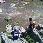
A roundabout portion off the C&O Canal Towpath, the Billy Goat Trail is rightfully a local favorite among hiking veterans and families. The trail stretches along the Potomac Gorge, a rocky, diverse 15-mile section of the Potomac River from above Great Falls and south to Theodore Roosevelt Island. The path itself is a tempered balance between dirt crosscuts woven through the lush forestry, and rugged cliff faces with sweeping views of the adjacent river, rock faces and woodlands. Convenient river access has also made it a popular destination for kayaking, canoeing and fishing.
The trail, broken into sections A, B and C, has varying levels of difficulty. Section A, stretching along Bear Island, while the most strenuous, is also the most frequented. And there are good reasons for this. Access to the trailhead is absurdly simple and conveniently located minutes outside the city – just off I-95 on MacArthur Boulevard, the parking area across from the Old Angler’s Inn. The path itself is a two-mile stretch along Bear Island, affording premiere vistas at the top of high rock faces that hikers must scramble up for the reward. The trail is something of a U-shape up the island, starting and ending at different points along the C&O Canal Towpath. Walking beside the reflective canal shaded by the forest’s florid, abundant eaves offers a nice cool-down from a challenging hike. The trail is almost always busy on a fair-weather day, so try and get there early to avoid the throngs.
Brookland
—
Description: 8.5 miles with shorter options. Easy.
The Brookland section of Northeast Washington is an unusual and distinctive area of the city. It in fact feels like a separate community from the District altogether, comprised of so many churches and school campuses, residential neighborhoods and historic cemeteries. Walking along any portion of the nearly all-pavement trail, you are bound to run into friendly people bursting with local pride. This natural diversity and serenity makes it one of the best neighborhood hikes in the area.
The trail in full circles around Catholic University, Rock Creek Cemetery and National Cemetery, as well as the Basilica of the National Shrine of the Immaculate Conception, cultural center, Brooks Mansion, Howard University Divinity School and an expanse of quiet neighborhoods.
This is the kind of hike where you put your dog on a leash, a smile on your face and be as sociable or contemplative as you see fit. It’s also right off the Metro red line at Brookland/CUA, so it doesn’t require any planning, so much as a slow afternoon and an itch for something experiential. En route, savor the striking exteriors, and consider returning another time to explore the interiors.
Capital Crescent Trail
—
Description: 11 miles in full with shorter options. Easy.
For much of the 20th century, the Capital Crescent Trail was the right-of-way of a railroad spur line that delivered coal and building supplies to the Georgetown waterfront. When the remaining coal customers switched to truck delivery in 1985, the rail line was closed, but in 1996 it was reopened as a recreational nature trail, affording inner city residents from Bethesda and D.C. backyard access to an unanticipated community walkway. Used largely as a neighborhood recreational trail, and abuzz year-round with cyclists, dog-walkers and stroller-toting joggers, the CCT has been heralded by the International Project for Public Places as one of the 21 greatest places that show how transportation can enliven a community.
If you’re looking for a good hike, Fletcher’s Boathouse would be a good starting point. It’s about two miles above Georgetown and can be navigated upstream along the Potomac until it veers off and takes you all the way up to Bethesda. Once in Bethesda, treat yourself to a well-deserved meal at any one of the scores of restaurants within the city proper.
Columbia Island
—
Description: 5.7 miles. Easy.
This is one of the city’s best-kept natural secrets. It’s hidden in plain sight, in the Potomac River across from the Lincoln Memorial. You might know it better as the beautiful forestry surrounding the GW Parkway with all those scenic outlooks over the Potomac onto mainland Washington. Surrounding the island, and crisscrossing over, under and around the shrouded parkways and arching, its concrete bridges and quiet pathways lie waiting to be explored. The 121-acre island has been designated by the National Park Services as Lady Bird Johnson Park to honor the then-First Lady’s efforts to beautify the country, and is now in rolling abundance with dogwoods, pines and flowering bushes. Access the trail from the Virginia side, where there is a juncture from the Mount Vernon trail.
Great Falls
—
Description: Expansive. 1 mile-10 miles. Easy to difficult.
Great Falls is nothing short of a national landmark. Frequenters of this national park (and there are many of us) are sure to see tourists, family picnickers and recreational events in droves up and down the expansive recreational areas. The flagship representative for purple mountain’s majesty in the nation’s capital, visitors come from around the world to glimpse the thundering waterfalls of the Potomac that separate Virginia and Maryland. Good weather will find the park packed to capacity, amateur photographers sardined around scenic overlooks. Experienced climbers are known to hop the ledge and climb down the rocky cliffs to the riverside and look up into the ferocious mouths of the falls. If you’re lucky, you’ll see a kayaker braving the extreme rapids and freefalling thirty feet from one exhilarating threshold to the next. But the real beauty of Great Falls is that it’s really two parks rolled up into one: The Virginia side and the Maryland side. Each half of the park has a wealth of dynamic pathways and sites to keep a hungry adventurer occupied for weeks.
The Virginia Side
The Virginia side of Great Falls boasts rugged trails and convenient riverfront access (though if you’re venturing all the way down there, convenience is to be gauged relatively). You will hear many locals refer leisurely to “rock scrambling” along the water, as the staggered and jagged cliff faces make for deliciously spontaneous rock climbing. The mountainous heights and plumbing depths in such immediate vicinity to one another create treasure troves of natural beauty hidden from view of the trails, such as a cliff-encircled, sandy beach with jungle-like shrubs, and a small lake that may recall that fishin’ hole Mr. Griffith always whistled so fondly about.
The Maryland Side
With a maze of raised plank walkways that take hikers through a seeming marshland of tall grasses and overhanging trees, and a towpath running along an adjacent canal further inland, the Maryland side of Great Falls is also a northward connection to the Billy Goat Trail, off MacArthur Blvd. The views of the waterfalls themselves are arguably more expansive than its sister park across the river, and creeks and streams that feed into the Potomac offer hikers peaceful, secluded resting sites to wait out the beating sun.
Kenilworth Aquatic Gardens and Marsh
—
Description: 2-4 miles. Easy.
For a hike within the city limits, just off Anacostia Avenue NE, the Kenilworth Aquatic Gardens and Marsh are disarmingly exotic and wild – and anything but urban. The Aquatic Gardens are part of the 77-acre marsh, located on the east bank of the Anacostia River. Within this marshland hikers will find tidy garden landscapes and small, explosive bursts of wilderness. Acres of water-lily ponds – containing enormous communities of butterflies – wildflowers, an impressive collection of flowering lotuses and tidal marshes rich with plant and wildlife patch together this diverse expanse of inner-city biodiversity. The water-lily blooming season lasts from May to September, and the land lilies are at their peak in June and July, so now is the perfect time to go experience the backyard you never knew existed.
Potomac Heritage Trail
—
Scotts Run to Roosevelt Island
Description: 11.5 miles in full with shorter options. Moderate difficulty.
The longest trail east of the Mississippi after the Appalachian, the Potomac Heritage Trail is a network of trails extending from Pennsylvania’s Laurel Highlands to the Chesapeake Bay, which includes more than 800 miles of trails that are in many cases, pre-existing arteries of a different name. This branching path system has long been touted as a premiere urban-area hike destination.
Scotts Run Nature Preserve is at the base of the GW Parkway, where this hike begins, and where you could take any number of roundabout hikes of a different destination, as this is the meeting point of a number of other trails. Additionally, there are no closer waterfalls to the D.C. area than those in Scotts Run. Head north up the trail, designated as a segment of the PHT, parallel to the parkway, and enjoy a meditative hike along the Potomac, where you will pass Fort Marcy, a well preserved Civil War fort, some private riverfront estates, a small, rocky gorge equipped with handrails and eventually get to Potomac Overlook Regional Park. As you come upon the end of your journey, eyeing Roosevelt Island while passing under the Key Bridge, you might find yourself amazed by the ever-expanding natural world just beyond your doorstep.
Rock Creek Park
—
Description: Expansive. 1 mile-10 miles. Easy to moderate difficulty.
Rock Creek Park was founded in 1890 as one of the first federal parks. When the park was founded, it was already a favorite area for rural retreat in the growing city of Washington. In the establishing legislation, Rock Creek Park was “dedicated and set apart as a public park or pleasure ground for the benefit and enjoyment of the people of the United States…[The park will] provide for the preservation from injury or spoliation of all timber, animals, or curiosities within said park, and their retention in their natural condition, as nearly as possible.”
On forest hills lie systems of Union Army fortifications from the Civil War, woven seamlessly into the dense wildlife of the surrounding area. Paths run around and throughout the historic park, highlighting the northern to southern regions. The hilly and often-ignored forests of the northern section are some of the city’s best hikes for complete emersion into nature. The unpaved trails are laden with horse tracks and wildlife abounds. The central area of Rock Creek is a popular area comprised of a rocky stream valley set amid the forestry. The premiere attraction is the Boulder Bridge, a (arguably) beautiful concrete arch bridge, adorned with boulder faces, that stretches across Rock Creek. Well-wooded parklands comprise the southern section, and the hikes, much like your favorite record, only get better by repeating the experience.
U.S. National Arboretum
—
Description: 8 miles in full with shorter options. Easy to moderate difficulty.
Though not as well known as perhaps it should be, the U.S. National Arboretum ranks among the city’s finest outdoor discoveries and easily the most botanically diverse hiking destination in or around the city. At almost 450 acres, the arboretum sits between New York Avenue and the Anacostia River. While it serves primarily as a U.S. Department of Agriculture horticultural research center, it is also a magnificent hiking destination that can overwhelm and dazzle the senses. Though deceivingly natural, the entire area is manmade, once but a plain tract of farmland. The scenery changes with each passing season, and communities of varying plants bloom through all 12 months, making it a great outdoor venue any time of year.
The scenery includes a five-acre forest of dwarf conifers, a single-trunk weeping blue Atlas cedar, an azalea grove, dawn redwoods (once believed to be extinct), tulip trees, a collection of plant life from Asia, Fern Valley, a wooded stream valley filled with Native American plants and even a collection of free-standing columns, once part of the Capital. There is more to be seen here than can be justly described in a few short paragraphs. We can only urge you to discover it for yourself.
Winkler Botanical Preserve
—
Description: 2 miles. Easy.
A private nature sanctuary hidden in western Alexandria, the Winkler Botanical Preserve is a great way to jump outside of the city without ever actually having to leave. With its small, easy network of hilly trail ways that stretch over 44 acres, there is much to be explored, including a small lake with several streams, a baby waterfall, meadow and covered bridge and even a bonafide Hobbit House. The playful scenery changes every few meters. Through its collection of 70 species of trees and around 650 species of flourishing wildflowers and plants, the Winkler family has created a private botanical preserve dedicated to serving as both a sanctuary and an institution specializing in trees and plants native to the Potomac River Valley. Guided tours of this preserve are monumentally beneficial, as it is so small and the plant life is unlabeled.
Beyond the Beltway:
—
Bull Run Mountains Natural Area
—
Description: Expansive. Moderate difficulty.
If you’re feeling more adventurous than usual, or simply have too much time on your hands, Bull Run is worth the drive. About thirty miles down I-66 at exit 40, the Bull Run Mountains are made up of a 16-mile mountain range that rises above the Piedmont area. Around Haymarket, this nature preserve offers hikers 2,500 acres of heavily wooded mountains to explore, including the headwaters of the Occoquan River, and one hell of a cliff-top vista of the surrounding area.
The trails are well preserved and labeled, with references to the area’s rich history. They are color-coded and appear on the preserve’s maps. Guided tours are available and summer camps for children even run throughout the summer from the preserve.


-

- Jordan Wright


-
- Jordan Wright