ANC Supports Big Plans for Water St.
By • May 11, 2020 0 1088
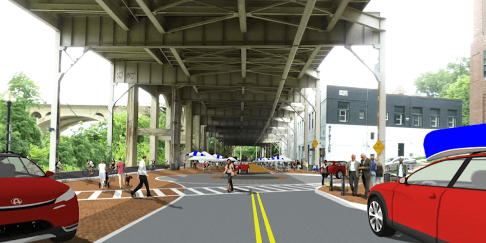
Preliminary plans by the District Department of Transportation to install “tactical” concrete sidewalks along the 3400-3500 blocks of Water Street NW, along with a two-way bikeway and a traffic roundabout — while making changes to on-street parking — were supported by the Georgetown-Burleith advisory neighborhood commission at its May 4 meeting. Public comment on the project is open until May 19.
“The main goal is to make the area safer,” according to Will Handsfield, former transportation director at the Georgetown Business Improvement District, who is now with DDOT’s Planning and Sustainability Division. “Currently, sidewalks in the area are discontinuous and in very poor condition, resulting in pedestrians walking in the street west of 34th Street, sharing this zone with, at times, high-speed traffic.” The roundabout, to be built at the intersection of 34th and Water Streets, is part of traffic calming efforts in the corridor, he said.
DDOT also plans to build a long-missing sidewalk “to ensure a continuous, separated path to reach facilities such as the boathouse, shops and cafes along the corridor and [provide] access to the Capital Crescent Trail.”
In addition, the speed limit will be reduced to 15 mph from 34th Street to the remnants of the Aqueduct Bridge and the “shared street” conditions will be improved from the Key Bridge Boathouse to the Aqueduct Bridge site.
The plans will impact parking in the area. Parking on the south side of the targeted Water Street area will be removed and the current perpendicular “back-in” parking on the north side will be switched to parallel parking. DDOT will install standard two-hour parking meters on the north side of Water Street, in operation from 9 a.m. to 10 p.m. “This at the request of the community, though we are open to different time limits upon request,” Handsfield commented.
“We’re not sure exactly how many current parking places will be impacted,” Advisory Neighborhood Commissioner Lisa Palmer told The Georgetowner. “This is not a final plan. Much of it is on a TBD status at present,” she said (that is, “To Be Decided”).
According to Handsfield: “The DDOT will continue the two-way protected bicycle facility to the Key Bridge Boathouse, and will mark the street with shared lane markings for 240 feet between that point and the start of the Capital Crescent Trail. This segment is an important step in expanding the protected bike lane network, now also used by scooters and other personal mobility devices. The K/Water Street Corridor has the highest recorded bicycle volumes in the region, averaging in excess of 3,000 riders per day in spring and fall.
“This design allows for several immediate improvements and benefits,” Handsfield told the commissioners. Those include a contiguous and safe bikeway designed around users between 8 and 80 years old, increased walking, biking and scooting trips in this area, reduction of conflicts between drivers, pedestrians and bikeway users, slower vehicular speeds, improved traffic control and fewer drivers circling to find parking. Improved lighting in this area will be integrated into the development plans for each site.
Comments on the preliminary plans have to be submitted in writing no later than May 19 via email to will.handsfield@dc.gov or to: District Department of Transportation, Planning and Sustainability Division, 55 M St. SE, 5th Floor, Washington, DC 20003.
